Picture of Pluto further refined by months of New Horizons data

Mike Summers, George Mason University

When the New Horizons spacecraft made its flyby of Pluto on July 14, 2015, there was worldwide celebration that we’d finally gotten our first detailed look at this completely new type of planet in the outer reaches of our solar system.

But for those of us on the New Horizons science team, that day and those first images were only the beginning. Since then, I’ve been watching with amazement as the New Horizons spacecraft has transmitted spectacular images back that reveal surprises all over the place. We’ve been making discovery after discovery about the dwarf ice planet Pluto and its moon Charon, and this is likely to continue as we get more data back from the spacecraft. Here’s a summary of just a few of our scientific results to date.

What do we see on Pluto’s surface?

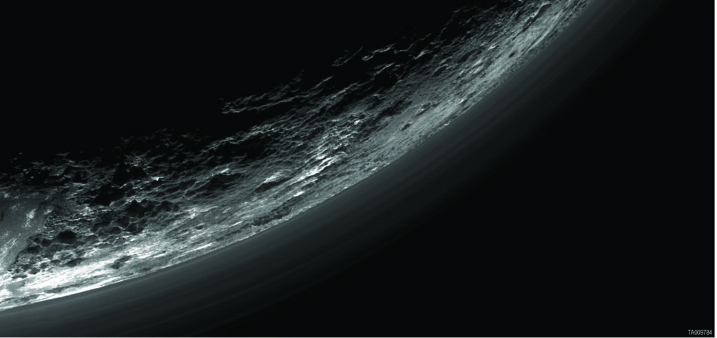
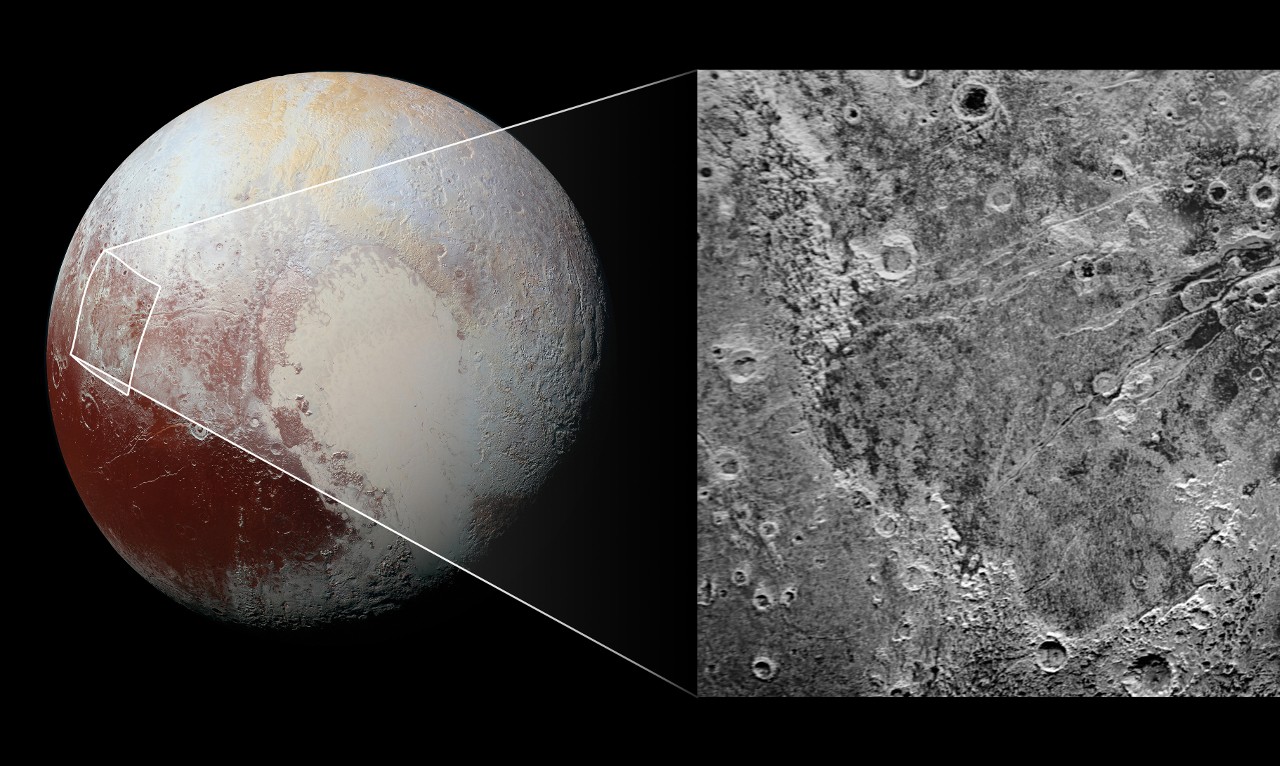
Perhaps one of the biggest surprises that was obvious from the very first images was that Pluto has a surface that is incredibly diverse.

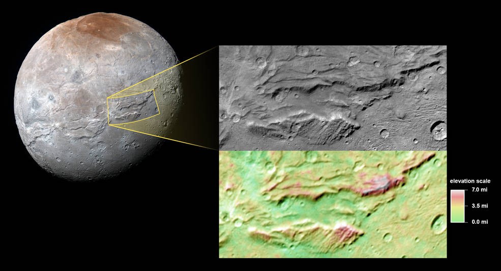
Some surface areas, such as those that are heavily cratered from asteroid impacts, seem to date back to just after Pluto formed, about 4.5 billion years ago. Other regions show evidence of geological activity that may have lasted throughout Pluto’s billions of years of history. Enormous ice volcanoes (cryovolcanoes) must have taken a large fraction of Pluto’s history to form. These volcanoes are driven by warm underground liquids, such as, perhaps, water and ammonia, instead of liquid rock-magma that we have on Earth, and their rough, crusty surface is made of stuff that has erupted from deep within Pluto’s interior.

Pluto’s Sputnik Planum captured hearts here on Earth. NASA/Johns Hopkins University Applied Physics Laboratory/Southwest Research Institute, CC BY

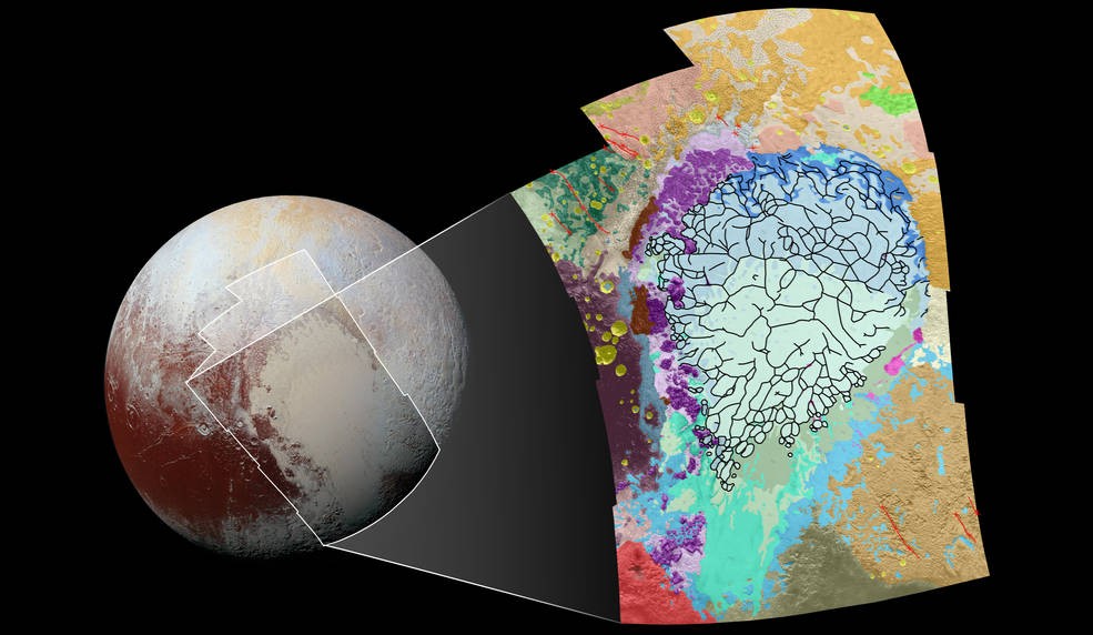
Other areas, such as the informally named Sputnik Planum – the heart-shaped, Texas-sized nitrogen ice glacier – show no evidence of asteroid impacts at all, suggesting continual surface activity, such as convection of ices from underground. This surface can’t be more than 10 million years old – a blink of the eye on a geological time scale!

Pluto is geologically active! I doubt there’s a single person on Earth who would have expected to see that!

[On the next page, learn what scientists now know about what Pluto is made of…]

[nextpagelink][/nextpagelink]

Pluto’s Giant “Bite Mark”

Scientists studying the surface of Pluto from the data returning from the New Horizons spacecraft have discovered what looks like a giant bit mark in the western hemisphere of the icy planet. Although researchers are still combing through the data to understand what’s eating Pluto, they have come up with some initial theories of what could be happening.

The location of the "bite" and closeup images of the area shown in visible light and via spectral analysis. Click/tap for higher resolution image. Credit: NASA
The location of the “bite” and closeup images of the area shown in visible light and via spectral analysis. Click/tap for higher resolution image. Credit: NASA

An informative feature on the NASA website dives into the details so far:

Far in the western hemisphere, scientists on NASA’s New Horizons mission have discovered what looks like a giant “bite mark” on Pluto’s surface. They suspect it may be caused by a process known as sublimation—the transition of a substance from a solid to a gas. The methane ice-rich surface on Pluto may be sublimating away into the atmosphere, exposing a layer of water-ice underneath.

Close up of the "bite." Click/tap for higher resolution image. Credit: NASA
Close up of the “bite.” Click/tap for higher resolution image. Credit: NASA

In this image, north is up. The southern portion of the left inset above shows the cratered plateau uplands informally named Vega Terra (note that all feature names are informal). A jagged scarp, or wall of cliffs, known as Piri Rupes borders the young, nearly crater-free plains of Piri Planitia. The cliffs break up into isolated mesas in several places.

Cutting diagonally across the mottled plans is the long extensional fault of Inanna Fossa, which stretches eastward 370 miles (600 kilometers) from here to the western edge of the great nitrogen ice plains of Sputnik Planum.

Compositional data from the New Horizons spacecraft’s Ralph/Linear Etalon Imaging Spectral Array (LEISA) instrument, shown in the right inset, indicate that the plateau uplands south of Piri Rupes are rich in methane ice (shown in false color as purple).  Scientists speculate that sublimation of methane may be causing the plateau material to erode along the face of the cliffs, causing them to retreat south and leave the plains of Piri Planitia in their wake.

Compositional data also show that the surface of Piri Planitia is more enriched in water ice (shown in false color as blue) than the higher plateaus, which may indicate that Piri Planitia’s surface is made of water ice bedrock, just beneath a layer of retreating methane ice.  Because the surface of Pluto is so cold, the water ice is rock-like and immobile. The light/dark mottled pattern of Piri Planitia in the left inset is reflected in the composition map, with the lighter areas corresponding to areas richer in methane – these may be remnants of methane that have not yet sublimated away entirely.

The inset at left shows about 650 feet (200 meters) per pixel; the image measures approximately 280 miles (450 kilometers) long by 255 miles (410 kilometers) wide. It was obtained by New Horizons at a range of approximately 21,100 miles (33,900 kilometers) from Pluto, about 45 minutes before the spacecraft’s closest approach to Pluto on July 14, 2015.

The LEISA data at right was gathered when the spacecraft was about 29,000 miles (47,000 kilometers) from Pluto; best resolution is 1.7 miles (2.7 kilometers) per pixel.

Source: NASA.gov – “What’s Eating at Pluto?”  Information published in accordance with NASA media usage guidelines and public domain rights.

Next, Check Out:


Never mind SpaceX’s Falcon 9, where’s my Millennium Falcon?

Fredrick Jenet, University of Texas Rio Grande Valley and Volker Quetschke, University of Texas Rio Grande Valley

Last week, SpaceX held another successful launch of its Falcon 9 rocket. Unfortunately, its landing was not quite as successful as the one in December (it crashed into the ocean).

SpaceX isn’t alone in trying to develop reusable launch vehicles. Other private companies such as Blue Origin and Virgin Galactic are also in the race to achieve the dream of consistently landing a rocket after hurtling it into the heavens. Each success – and failure – gets us a little closer.

But how significant is the creation of reusable rockets? And where will we go from here? Are we finally close to the future once promised by the Jetson’s FX-Atmos “flying car” or Han Solo’s Millennium Falcon: a world of personal, space-bound transports that can leave your garage, reach orbit and beyond, and return home in time for dinner?

What else stands in the way?

The final frontier

The “democratization of space exploration,” spurred by NASA encouraging private companies to develop and manage complete launch systems, is igniting a new age of space development and awakening a spirit of exploration and technology innovation that’s been absent from our culture for far too long.

This resurgence of interest is reflected in NASA’s latest call for astronaut applications: 18,300 hopefuls applied for just 14 positions.

And in the private sector, venture capitalists are showing the same enthusiasm by investing US$1.8 billion in space startups in 2015, compared with an average of $193 million a year over the previous 15 years. The increased demand for space access is further spurring on private companies to develop more efficient reusable rocket launch systems.

Today’s space companies aren’t the first to set their sights on such a rocket. This great feat of engineering was originally achieved in 1993, when McDonald Douglass tested the Delta Clipper Experimental (DC-X), a prototype single-stage launch vehicle. NASA later canceled the project.

Now, it seems, the conditions are ripe once again to pick up where the DC-X left off. The private sector has started to take up this challenge, and the race is on to enhance all our lives with cheap space travel.

This future begins with the reusable rocket.

[Article Continues on Next Page…]

[nextpagelink][/nextpagelink]

Details About Huge Mountain on Ceres Emerge

Just past it’s 1-year anniversary of sliding into obit around the dwarf planet Ceres, NASA’s Dawn spacecraft has sent back the most detailed images of the huge mountain that’s very existence on Ceres is a mystery to scientists. Dawn’s orbit of Ceres also made history for NASA, because that accomplishment made Dawn the first spacecraft to orbit two different extraterrestrial objects. It had previously achieved orbit around Vesta in 2011 and spent about a year completing a detailed imaging and mapping mission there.

The new images from Ceres reveal a mountain that rises about 2.5 miles above the surface of the dwarf planet, making it as tall as Mt. Rainier in Washington State.

Ceres' mysterious mountain Ahuna Mons is seen in this mosaic of images from NASA's Dawn spacecraft. Dawn took these images from its lowest-altitude orbit. Credits: NASA/JPL-Caltech/UCLA/MPS/DLR/IDA
Ceres’ mysterious mountain Ahuna Mons is seen in this mosaic of images from NASA’s Dawn spacecraft. Dawn took these images from its lowest-altitude orbit. Click/tap image for larger size.
Credits: NASA/JPL-Caltech/UCLA/MPS/DLR/IDA

A fact-packed article on the NASA website supplies the fascinating details:

One year ago, on March 6, 2015, NASA’s Dawn spacecraft slid gently into orbit around Ceres, the largest body in the asteroid belt between Mars and Jupiter.  Since then, the spacecraft has delivered a wealth of images and other data that open an exciting new window to the previously unexplored dwarf planet.

“Ceres has defied our expectations and surprised us in many ways, thanks to a year’s worth of data from Dawn. We are hard at work on the mysteries the spacecraft has presented to us,” said Carol Raymond, deputy principal investigator for the mission, based at NASA’s Jet Propulsion Laboratory, Pasadena, California.

Among Ceres’ most enigmatic features is a tall mountain the Dawn team named Ahuna Mons. This mountain appeared as a small, bright-sided bump on the surface as early as February 2015 from a distance of 29,000 miles (46,000 kilometers), before Dawn was captured into orbit. As Dawn circled Ceres at increasingly lower altitudes, the shape of this mysterious feature began to come into focus. From afar, Ahuna Mons looked to be pyramid-shaped, but upon closer inspection, it is best described as a dome with smooth, steep walls.

This side-perspective view of the mysterious mountain Ahuna Mons in 3D was made with images from NASA's Dawn spacecraft. Click/tap for larger image. Credits: NASA/JPL-Caltech/UCLA/MPS/DLR/IDA
This side-perspective view of the mysterious mountain Ahuna Mons in 3D was made with images from NASA’s Dawn spacecraft. Click/tap for larger image.
Credits: NASA/JPL-Caltech/UCLA/MPS/DLR/IDA

The article continues:

Dawn’s latest images of Ahuna Mons, taken 120 times closer than in February 2015, reveal that this mountain has a lot of bright material on some of its slopes, and less on others. On its steepest side, it is about 3 miles (5 kilometers) high. The mountain has an average overall height of 2.5 miles (4 kilometers). It rises higher than Washington’s Mount Rainier and California’s Mount Whitney.

Scientists are beginning to identify other features on Ceres that could be similar in nature to Ahuna Mons, but none is as tall and well-defined as this mountain.

“No one expected a mountain on Ceres, especially one like Ahuna Mons,” said Chris Russell, Dawn’s principal investigator at the University of California, Los Angeles. “We still do not have a satisfactory model to explain how it formed.”

About 420 miles (670 kilometers) northwest of Ahuna Mons lies the now-famous Occator Crater. Before Dawn arrived at Ceres, images of the dwarf planet from NASA’s Hubble Space Telescopeshowed a prominent bright patch on the surface. As Dawn approached Ceres, it became clear that there were at least two spots with high reflectivity. As the resolution of images improved, Dawn revealed to its earthly followers that there are at least 10 bright spots in this crater alone, with the brightest area on the entire body located in the center of the crater. It is not yet clear whether this bright material is the same as the material found on Ahuna Mons.

“Dawn began mapping Ceres at its lowest altitude in December, but it wasn’t until very recently that its orbital path allowed it to view Occator’s brightest area. This dwarf planet is very large and it takes a great many orbital revolutions before all of it comes into view of Dawn’s camera and other sensors,” said Marc Rayman, Dawn’s chief engineer and mission director at JPL.

For additional details and more photos of Ahuna Mons and the Occator Crater, please see the excellent feature on the NASA.gov website.

Source: NASA.gov –  “Dawn’s First Year at Ceres: A Mountain Emerges”

Now, Check Out:

#YearInSpace: The Science Behind Scott Kelly’s Mission [Infographic]

By having astronaut Scott Kelly spend a year in space, what is NASA intending to learn? Overall, they are studying what happens to the human body during extended periods of time in zero or microgravity situations, to see what we can expect for long-duration spaceflight. Kelly’s year on the International Space Station should provide researchers with many specific answers.

The infographic below from NASA provides a great summary of the studies in progress on Scott Kelly (click/tap for larger image):

Web

Source: #YearInSpace infographic and featured photo courtesy of NASA

Now, Check Out:

[Video] Studying Vision and Circulation Problems for Space Station Astronauts

About three-quarters of all astronauts that spend time on the International Space Station (ISS) end up with changes in their vision, which is actually due to structural changes in their eyes themselves. And those changes are actually due to changes in the way fluids move in their bodies while in space.

This great video from NASA tells the whole story:

Thanks to the Science at NASA YouTube channel for this great video!

Now, Check Out:

One-Year ISS Crew Returning to Earth on March 1: Complete Coverage Schedule

NASA Television will provide complete coverage Tuesday, March 1, as three crew members depart the International Space Station, including NASA astronaut Scott Kelly and cosmonaut Mikhail Kornienko of the Russian space agency Roscosmos – the station’s first one-year crew.

NASA Television coverage will begin at 3:10 p.m. EST on Monday, Feb. 29, when Kelly hands over command of the station to fellow NASA astronaut Tim Kopra. Complete coverage is as follows:

Monday, Feb. 29

  • 3:10 p.m. — Change of command ceremony (Scott Kelly hands over space station command to Tim Kopra)

Tuesday, March 1

  • 4:15 p.m. — Farewell and hatch closure coverage; hatch closure scheduled at 4:40 p.m.
  • 7:45 p.m. — Undocking coverage; undocking scheduled at 8:05 p.m.
  • 10:15 p.m. — Deorbit burn and landing coverage; deorbit burn scheduled at 10:34 p.m., with landing at 11:27 p.m. (10:27 a.m. on March 2, Kazakhstan time)

Wednesday, March 2

  • 1:30 a.m. — Video file of hatch closure, undocking and landing activities
NASA astronaut Scott Kelly and Russian cosmonaut Mikhail Kornienko marked their 300th consecutive day aboard the International Space Station on Jan. 21, 2016. The pair will land March 1 after spending a total of 340 days in space. Credits: NASA
NASA astronaut Scott Kelly and Russian cosmonaut Mikhail Kornienko marked their 300th consecutive day aboard the International Space Station on Jan. 21, 2016. The pair will land March 1 after spending a total of 340 days in space.
Credits: NASA

Twice the duration of a typical mission, Kelly and Kornienko’s station-record 340 days in space afforded researchers a rare opportunity to study the medical, physiological, and psychological and performance challenges astronauts face during long-duration spaceflight.

The science driving the one-year mission, critical to informing the agency’s Journey to Mars, began a year before Kelly or Kornienko floated into the space station. Biological samples were collected and assessments were performed in order to establish baselines. Comparison samples were taken throughout their stay in space and will continue for a year or more after their return to Earth. Kelly’s identical twin brother, former NASA astronaut Mark Kelly, participated in parallel twin studies on Earth to provide scientists more bases for comparisons.

ISS Expedition 47 officially begins, under Kopra’s command, when the Soyuz carrying Kelly, Kornienko and Volkov undocks from the space station. Kopra, Yuri Malenchenko of Roscosmos and Tim Peake of ESA (European Space Agency), will operate the station as a three-person crew until the arrival of three new crew members in two weeks. NASA astronaut Jeff Williams and Roscosmos cosmonauts Alexey Ovchinin and Oleg Skripochka are scheduled to launch from Baikonur, Kazakhstan, on March 18 EST.

For NASA TV streaming video and schedule, visit:  http://www.nasa.gov/nasatv

Article content courtesy of NASA.

Now, Check Out:

Pluto’s Charon Looks to be the ‘Incredible Hulk’ of Moons

NASA scientists studying images of Pluto’s largest moon, Charon, from the New Horizons flyby data have discovered a fascinating feature of the surface of that moon: like the Incredible Hulk growing too big for his shirt, its surface is covered with “pull-apart” faults indicating that it has expanded and cracked.

A very interesting article on the NASA website provides the details of this fantastic situation:

Pluto’s largest moon may have gotten too big for its own skin.

Images from NASA’s New Horizons mission suggest that Pluto’s moon Charon once had a subsurface ocean that has long since frozen and expanded, pushing outward and causing the moon’s surface to stretch and fracture on a massive scale.

The side of Pluto’s largest moon viewed by NASA’s passing New Horizons spacecraft in July 2015 is characterized by a system of “pull apart” tectonic faults, which are expressed as ridges, scarps and valleys—the latter sometimes reaching more than 4 miles (6.5 kilometers) deep. Charon’s tectonic landscape shows that, somehow, the moon expanded in its past, and – like Bruce Banner tearing his shirt as he becomes the Incredible Hulk – Charon’s surface fractured as it stretched.

The outer layer of Charon is primarily water ice. This layer was kept warm when Charon was young by heat provided by the decay of radioactive elements, as well as Charon’s own internal heat of formation. Scientists say Charon could have been warm enough to cause the water ice to melt deep down, creating a subsurface ocean. But as Charon cooled over time, this ocean would have frozen and expanded (as happens when water freezes), lifting the outermost layers of the moon and producing the massive chasms we see today.


nh-charon_serenitychasma_context_02182016_melded
A close-up of the canyons on Charon, Pluto’s big moon, taken by New Horizons during its close approach to the Pluto system last July. Multiple views taken by New Horizons as it passed by Charon allow stereo measurements of topography, shown in the color-coded version of the image. The scale bar indicates relative elevation. Credits: NASA/JHUAPL/SwRI. Click image for larger view.


The top portion of this image shows part of the feature informally named Serenity Chasma, part of a vast equatorial belt of chasms on Charon. This system of faults and fractures runs at least 1,100 miles (about 1,800 kilometers) long and in places there are chasms 4.5 miles (7.5 kilometers) deep. By comparison, the Grand Canyon is 277 miles (446 kilometers) long and just over a mile (1.6 kilometers) deep.

The lower portion of the image shows color-coded topography of the same scene. Measurements of the shape of this feature tell scientists that Charon’s water ice layer may have been at least partially liquid in its early history, and has since refrozen.

This image was obtained by the Long-Range Reconnaissance Imager (LORRI) on New Horizons. North is up; illumination is from the top-left of the image. The image resolution is about 1,290 feet (394 meters) per pixel. The image measures 240 miles (386 kilometers) long and 110 miles (175 kilometers) wide. It was obtained at a range of approximately 48,900 miles (78,700 kilometers) from Charon, about an hour and 40 minutes before New Horizons’ closest approach to Charon on July 14, 2015.

NASA scientists continue to be amazed by the geological features of both Pluto and Charon that have been revealed by the New Horizons mission, and since the data is still streaming back from the spacecraft, we can expect a lot more to come.

Source: NASA.gov – “Pluto’s ‘Hulk-like’ Moon Charon: A Possible Ancient Ocean?” Materials republished per the NASA media guidelines and public domain rights.

Next, Check Out:

How Growing Zinnia Flowers on the Space Station Relates to Deep-Space Food Production

Zinnia plants from the Veggie ground control experiment at NASA’s Kennedy Space Center in Florida were harvested Feb. 11 in the same way that crew member Scott Kelly also harvested the zinnias growing in the Veggie system aboard the International Space Station on Feb. 14—Valentine’s Day. Flowering plants will help scientists learn more about growing crops for deep-space missions and NASA’s journey to Mars.

The ground plants didn’t experience some of the same stressors as those grown simultaneously on the ISS — like unexpected fungus growth. However, some of the zinnia plants aboard the floating laboratory pulled through due to collaboration between the astronauts and the ground team at Kennedy. Ultimately, the experiment that went off-script when astronaut Scott Kelly became an autonomous gardener, provided researchers with even more information about how to effectively grow plants in space than they expected.

Photos of the Ground Zinnias' Harvesting inside the SSPF
Chuck Spern, a project engineer with Vencore on the Engineering Services Contract, removes the base tray containing zinnias from a controlled environment chamber in the Space Station Processing Facility at NASA’s Kennedy Space Center in Florida. (Photo credit: NASA/Bill White)

“I think we’ve learned a lot about doing this kind of experiment. We’re being farmers in space,” Kelly said. “I was extra motivated to bring the plants back to life.”

“We need to learn a tremendous amount to help develop more robust sustainable food production systems as NASA moves toward long-duration exploration and the journey to Mars,” said Gioia Massa, NASA Kennedy payload scientist for Veggie.

Researchers hope to gather good data regarding long-duration seed stow and germination. Also, whether pollen could affect crew health and how having growing colorful flowering plants to grow could improve crew morale

Veggie is the biggest plant/flower experiment to fly on the station. Experiments involving space plants have been a favorite of astronauts, especially those staying in space for long durations like Scott Kelly. According to behavioral health scientists, part of the pleasure for astronauts is just being involved in meaningful work. But crews in space aren’t the only ones positively affected by growing plants.

“We are sad to see them go,” said Chuck Spern, a project engineer with Vencore on the Engineering Services Contract at Kennedy, “We’ve been caring for them for quite a while. But it’s for the interest of science so we can go to Mars.”

At Kennedy, Spern removed the Veggie base tray from a controlled environment chamber in the Space Station Processing Facility, and moved it to the Flight Equipment Development Laboratory for harvesting.

Continue reading to learn the details about the experiment and why it will help with understanding crop production on future deep-space missions.

[nextpagelink][/nextpagelink]

From Pluto With Love

Just in time for Valentine’s Day, NASA has release a new image analysis of the “heart of Pluto” which looks like psychedelic artwork, but is actually some very serious science. This image is a compilation of  12 different images of the heart taken by the Long Range Reconnaissance Imager (LORRI) on the New Horizons spacecraft. The resulting image was then overlaid with colors representing the various types of geological features observed, creating this final image:

pluto-geology-key
Map of the informally-named Sputnik Planum with color key for the various geological features. (Credit: NASA/JHUAPL/SwRI) Click for higher-resolution image.

This next image shows the location of the analysis in relationship Pluto’s heart:

Overlay of the area of the geological analysis image on the surface of Pluto. (Credit NASA/JHUAPL/SwRI). Click for higher-resolution image.

The NASA website provides a detailed explanation of the image and how scientists are using it to understand more about the nature of Pluto’s geology:

How to make sense of Pluto’s surprising geological complexity? To help understand the diversity of terrain and to piece together how Pluto’s surface has formed and evolved over time, mission scientists construct geological maps like the one shown above.

This map covers a portion of Pluto’s surface that measures 1,290 miles (2,070 kilometers) from top to bottom, and includes the vast nitrogen-ice plain informally named Sputnik Planum and surrounding terrain.  As the key in the figure below indicates, the map is overlaid with colors that represent different geological terrains.  Each terrain, or unit, is defined by its texture and morphology – smooth, pitted, craggy, hummocky or ridged, for example.  How well a unit can be defined depends on the resolution of the images that cover it.  All of the terrain in this map has been imaged at a resolution of approximately 1,050 feet (320 meters) per pixel or better, meaning scientists can map units with relative confidence.

The various blue and greenish units that fill the center of the map represent different textures seen across Sputnik Planum, from the cellular terrain in the center and north, to the smooth and pitted plains in the south.  The black lines represent troughs that mark the boundaries of cellular regions in the nitrogen ice.  The purple unit represents the chaotic, blocky mountain ranges that line Sputnik’s western border, and the pink unit represents the scattered, floating hills at its eastern edge.  The possible cryovolcanic feature informally named Wright Mons is mapped in red in the southern corner of the map.  The rugged highlands of the informally named Cthulhu Regio are mapped in dark brown along the western edge, pockmarked by many large impact craters, shown in yellow.

By studying how the boundaries between units crosscut one another, mission scientists can determine which units overlie others, and assemble a relative chronology for the different units. For example, the yellow craters (at left, on the western edge of the map) must have formed after their surrounding terrain. Producing such maps is important for gauging what processes have operated where on Pluto, and when they occurred relative to other processes at work.

The base map for this geologic map is a mosaic of 12 images obtained by the Long Range Reconnaissance Imager (LORRI) at a resolution of 1,280 feet (about 390 meters) per pixel.  The mosaic was obtained at a range of approximately 48,000 miles (77,300 kilometers) from Pluto, about an hour and 40 minutes before New Horizons’ closest approach on July 14, 2015.

For all the details and even higher resolution images, check out the excellent short article on the NASA website.

Source: NASA.gov – “Putting Pluto’s Geology on the Map

Next, Check Out: